
1952 Map of Rockfield
USGS Topo · Published 1953About this map
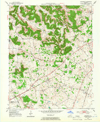
Rockfield serves as a central hub in this Warren County landscape, where the Louisville and Nashville railroad and the Louisville Jefferson Davis and Nashville Highway parallel one another through the karst-influenced terrain. The area is marked by a significant concentration of Oil Wells and several Quarry sites, particularly in the northern reaches near Briggs Hill and Blue Level. This industrial footprint is interspersed with established rural communities like Rich Pond and Petros. Local history and genealogy are anchored by numerous country churches and cemeteries, such as Providence Ch and Pleasant Hill Cem, alongside early educational landmarks like Salem Sch. The map reveals a mid-century economy where transportation and resource extraction shaped the development of these small Kentucky settlements.
Find a feature on this map
27 named features on this map. Tap any name to fly to it.
Don’t see what you’re looking for? This feature index may not catch every label — zoom into the map to look around manually.
Map Details
Editions of this 1952 Rockfield Map
2 editions found
Other maps of this area

1914 · Little Muddy
USGS Topo · 1:62,500

1921 · Bowling Green
USGS Topo · 1:62,500

1922 · Brownsville
USGS Topo · 1:62,500

1923 · Bowling Green
USGS Topo · 1:62,500

1923 · Brownsville
USGS Topo · 1:62,500

1951 · Woodburn
USGS Topo · 1:24,000

1951 · Auburn
USGS Topo · 1:24,000

1951 · South Union
USGS Topo · 1:24,000

1954 · Evansville
USGS Topo · 1:250,000

1954 · Bowling Green North
USGS Topo · 1:24,000