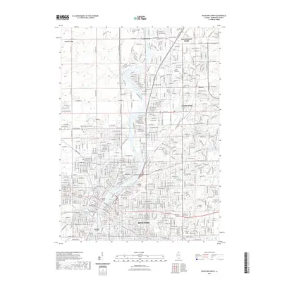
2021 Map of Rockford North
USGS Topo · Published 2021About this map
The Rock River carves a deep path through northern Illinois, anchoring a dense network of suburban and urban development that includes Rockford, Loves Park, and Machesney Park. This modern survey reveals a landscape where historical burial grounds such as Cedar Bluff Cem, Greenwood Cem, and the Rockford Hebrew Cem are preserved amidst a complex street grid. The river valley is punctuated by geographic landmarks like Lookout Point and Turtle Mound, while institutions such as Rockford University and the Winnebago County Courthouse define the city's civic and educational core. To the north, the transition from industrial and residential centers toward the more open terrain of Owen Center and Latham Park is visible, centered around the Spickard-Marshall Airport. This documentation provides a contemporary view of the region's infrastructure, from the major corridors of E State St and Harlem Rd to the recreational space at Sunset Memorial Gardens.
Find a feature on this map
47 named features on this map. Tap any name to fly to it.
Don’t see what you’re looking for? This feature index may not catch every label — zoom into the map to look around manually.
Map Details
Editions of this 2021 Rockford North Map
This is the sole edition of this map. No revisions or reprints were ever made.
Other maps of this area

1917 · Kings
USGS Topo · 1:62,500

1918 · Rockford
USGS Topo · 1:62,500

1918 · Belvidere
USGS Topo · 1:62,500

1918 · Kings
USGS Topo · 1:62,500

1918 · Kirkland
USGS Topo · 1:62,500

1938 · Rockford
USGS Topo · 1:62,500

1944 · Belvidere
USGS Topo · 1:62,500

1949 · Camp Grant
USGS Topo · 1:24,000

1949 · Rockford
USGS Topo · 1:24,000

1954 · Rockford
USGS Topo · 1:250,000