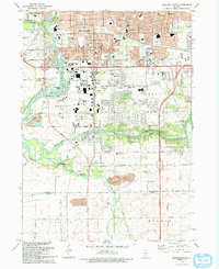
1993 Map of Rockford South
USGS Topo · Published 1993About this map
The confluence of the Rock River and the Kishwaukee River anchors this landscape just south of Rockford in the early 1990s. The area exhibits a dense concentration of public education and conservation sites, from schools like Riverdahl Sch and Thomas Jefferson High Sch to the expansive Kishwaukee Gorge North County Forest Preserve. Transportation infrastructure is a dominant theme, with the sprawling Greater Rockford Airport and the steel arteries of the Chicago and North Western and Chicago Milwaukee St Paul and Pacific railroads. Moving south from the industrial edges of the city, the terrain transitions into the smaller settlement of New Milford and the rural reaches of Harrisville, where numerous quarries and gravel pits suggest a landscape defined by resource extraction near the Kilbuck Creek basin.
Find a feature on this map
77 named features on this map. Tap any name to fly to it.
Don’t see what you’re looking for? This feature index may not catch every label — zoom into the map to look around manually.
Map Details
Editions of this 1993 Rockford South Map
This is the sole edition of this map. No revisions or reprints were ever made.
Other maps of this area

1917 · Kings
USGS Topo · 1:62,500

1918 · Rockford
USGS Topo · 1:62,500

1918 · Belvidere
USGS Topo · 1:62,500

1918 · Kings
USGS Topo · 1:62,500

1918 · Kirkland
USGS Topo · 1:62,500

1938 · Rockford
USGS Topo · 1:62,500

1944 · Belvidere
USGS Topo · 1:62,500

1949 · Camp Grant
USGS Topo · 1:24,000

1949 · Rockford
USGS Topo · 1:24,000

1954 · Rockford
USGS Topo · 1:250,000