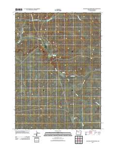
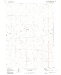
2011 Map of Rockhouse Reservoir
USGS Topo · Published 2011About this map
Rockhouse Reservoir and Blevins Reservoir anchor this arid high-desert landscape in southeastern Oregon. The terrain is defined by a dendritic network of seasonal drainages, where Dry Creek and Corbin Creek carve through the basin toward White Mule Flat. Human presence is sparse, marked primarily by isolated water management features and a single named corridor, Indian Fort Creek Rd, which tracks alongside Indian Fort Creek in the northern reach. This survey illustrates the essential role of artificial reservoirs in sustaining livestock or wildlife in a region where natural water flow is ephemeral. The infrastructure recorded here reveals how grazing and water rights shaped the land use patterns of Malheur County in the early twenty-first century.
Find a feature on this map
7 named features on this map. Tap any name to fly to it.
Don’t see what you’re looking for? This feature index may not catch every label — zoom into the map to look around manually.
Map Details
Editions of this 2011 Rockhouse Reservoir Map
This is the sole edition of this map. No revisions or reprints were ever made.
Other maps of this area

1955 · Jordan Valley
USGS Topo · 1:250,000

1957 · Jordan Valley
USGS Topo · 1:250,000

1958 · Jordan Valley
USGS Topo · 1:250,000
1969 · Dry Creek Rim
USGS Topo · 1:24,000

1972 · Rome
USGS Topo · 1:24,000
1972 · Scott Reservoir
USGS Topo · 1:24,000

1979 · Rockhouse Reservoir
USGS Topo · 1:24,000

1979 · Bowden Ranch
USGS Topo · 1:24,000
1979 · The Basin
USGS Topo · 1:24,000
1980 · Caviatta Ridge
USGS Topo · 1:24,000