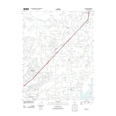
2012 Map of Rocklin
USGS Topo · Published 2012About this map
Rocklin and Roseville anchor the southern corridor of this Placer County survey, where suburban development meets the historical irrigation infrastructure of the Sierra Nevada foothills. The landscape is defined by an intricate network of waterways, including the Boardman Canal, Antelope C Canal, and Tumer Canal, reflecting the region's long-standing reliance on diverted water for agriculture and settlement. The Southern Pacific RR cuts a diagonal path through the terrain, passing through the established centers of Loomis, Penryn, and Newcastle. Evidence of the area's varied land use is visible in features ranging from the Sierra College campus to the Holsclaws Stol Strip Stolport. To the east, the map captures the transition to the recreation-focused shoreline at Granite Bay and Beeks Bight on Folsom Lake, while northern sections near Boulder Ridge maintain a more rural character with family-named crossings like Stallman Corners.
Find a feature on this map
156 named features on this map. Tap any name to fly to it.
Don’t see what you’re looking for? This feature index may not catch every label — zoom into the map to look around manually.
Map Details
Editions of this 2012 Rocklin Map
This is the sole edition of this map. No revisions or reprints were ever made.
Other maps of this area

1891 · Sacramento
USGS Topo · 1:125,000

1892 · Sacramento
USGS Topo · 1:125,000

1893 · Sacramento
USGS Topo · 1:125,000

1902 · Fairoaks
USGS Topo · 1:62,500

1910 · Lincoln
USGS Topo · 1:31,680

1910 · Roseville
USGS Topo · 1:31,680

1911 · Antelope
USGS Topo · 1:31,680

1914 · Folsom
USGS Topo · 1:31,680

1941 · Folsom
USGS Topo · 1:62,500
1942 · Markham Ravine
USGS Topo · 1:62,500