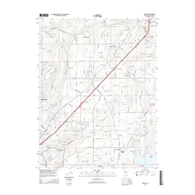
2015 Map of Rocklin
USGS Topo · Published 2015About this map
Rocklin serves as a central hub in this modern topographic landscape, where suburban expansion meets a complex network of historic water management features. The area's topography is defined by prominent rises like Boulder Ridge and Sugarloaf, while the southern reaches meet the northern shoreline of Folsom Lake at Dotons Point. The distribution of residential communities such as Granite Bay and Hidden Valley is closely tied to the traditional water routes of the Boardman Canal and Baughman Canal, highlighting how 19th-century infrastructure continues to shape modern land use.
Find a feature on this map
29 named features on this map. Tap any name to fly to it.
Don’t see what you’re looking for? This feature index may not catch every label — zoom into the map to look around manually.
Map Details
Editions of this 2015 Rocklin Map
This is the sole edition of this map. No revisions or reprints were ever made.
Other maps of this area

1891 · Sacramento
USGS Topo · 1:125,000

1892 · Sacramento
USGS Topo · 1:125,000

1893 · Sacramento
USGS Topo · 1:125,000

1902 · Fairoaks
USGS Topo · 1:62,500

1910 · Lincoln
USGS Topo · 1:31,680

1910 · Roseville
USGS Topo · 1:31,680

1911 · Antelope
USGS Topo · 1:31,680

1914 · Folsom
USGS Topo · 1:31,680

1941 · Folsom
USGS Topo · 1:62,500
1942 · Markham Ravine
USGS Topo · 1:62,500