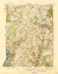
1945 Map of Rockville
USGS Topo · Published 1945About this map
Rockville serves as the focal point for this mid-1940s landscape, illustrating the transition from rural Montgomery County to a burgeoning suburban hub. The town is anchored by the Baltimore and Ohio railroad corridor, which links smaller outlying communities such as Beantown, Westmore, and Derwood. To the west, the terrain remains dominated by extensive creek systems like Muddy Branch and Watts Branch, while the southwestern edge is defined by the Potomac River.
Find a feature on this map
49 named features on this map. Tap any name to fly to it.
Don’t see what you’re looking for? This feature index may not catch every label — zoom into the map to look around manually.
Map Details
Editions of this 1945 Rockville Map
2 editions found
Other maps of this area

1890 · Mt. Vernon
USGS Topo · 1:125,000

1891 · Mt. Vernon
USGS Topo · 1:125,000

1893 · Frederick
USGS Topo · 1:125,000

1894 · Frederick
USGS Topo · 1:125,000

1894 · Mt. Vernon
USGS Topo · 1:125,000

1897 · Mt. Vernon
USGS Topo · 1:125,000

1900 · Washington
USGS Topo · 1:62,500

1908 · Rockville
USGS Topo · 1:62,500

1908 · Seneca
USGS Topo · 1:62,500

1915 · Fairfax
USGS Topo · 1:62,500