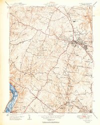
1951 Map of Rockville
USGS Topo · Published 1951About this map
Rockville serves as the central hub for this mid-century portrait of Montgomery County, Maryland, where the post-war suburban shift begins to redefine the landscape. Major transit routes like Viers Mill Rd, Rockville Pike, and the Baltimore and Ohio railroad corridor illustrate the community's connection to the broader region. Along the western edge, the Potomac River and the Chesapeake and Ohio Canal (Abandoned) represent the earlier industrial and transport era, now giving way to residential developments like Pine Knolls and Willerburn Acres.
Find a feature on this map
68 named features on this map. Tap any name to fly to it.
Don’t see what you’re looking for? This feature index may not catch every label — zoom into the map to look around manually.
Map Details
Editions of this 1951 Rockville Map
2 editions found
Other maps of this area

1890 · Mt. Vernon
USGS Topo · 1:125,000

1891 · Mt. Vernon
USGS Topo · 1:125,000

1893 · Frederick
USGS Topo · 1:125,000

1894 · Frederick
USGS Topo · 1:125,000

1894 · Mt. Vernon
USGS Topo · 1:125,000

1897 · Mt. Vernon
USGS Topo · 1:125,000

1900 · Washington
USGS Topo · 1:62,500

1908 · Rockville
USGS Topo · 1:62,500

1908 · Seneca
USGS Topo · 1:62,500

1915 · Fairfax
USGS Topo · 1:62,500