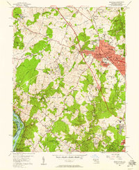
1956 Map of Rockville
USGS Topo · Published 1958About this map
The Baltimore and Ohio RR corridor defines the mid-century growth of Rockville, serving as a backbone for industrial and institutional development. This era captures the city's suburban evolution, evidenced by a dense network of educational facilities like Lincoln Jr High Sch and Carver High Sch, alongside civic landmarks including the Courthouse and City Hall. To the east, the Congressional Airport represents a vanishing era of early aviation before modern expansion reshaped the county's transit landscape.
Find a feature on this map
120 named features on this map. Tap any name to fly to it.
Don’t see what you’re looking for? This feature index may not catch every label — zoom into the map to look around manually.
Map Details
Editions of this 1956 Rockville Map
2 editions found
Other maps of this area

1890 · Mt. Vernon
USGS Topo · 1:125,000

1891 · Mt. Vernon
USGS Topo · 1:125,000

1893 · Frederick
USGS Topo · 1:125,000

1894 · Frederick
USGS Topo · 1:125,000

1894 · Mt. Vernon
USGS Topo · 1:125,000

1897 · Mt. Vernon
USGS Topo · 1:125,000

1900 · Washington
USGS Topo · 1:62,500

1908 · Rockville
USGS Topo · 1:62,500

1908 · Seneca
USGS Topo · 1:62,500

1915 · Fairfax
USGS Topo · 1:62,500