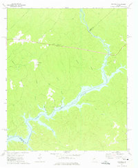
1972 Map of Rockville
USGS Topo · Published 1975About this map
Rockville serves as the central hub of this rural landscape in the early 1970s, where several country churches anchor the local community. The map shows a clear network of spiritual and social centers, including Jenkins Grove Chapel, Mt Zion Ch, Oconee Ch, and St Pauls Ch. The eastern and southern portions of the terrain are dominated by the waters of the Oconee River and Lake Sinclair, which marks the boundary between Putnam, Greene, and Hancock Counties. Numerous small waterways like Buckshot Creek and Sandy Run carve through the forested hills, feeding into the larger reservoir. At the heart of the settlement, the Rockville Lookout Tower stands as a notable landmark overlooking the intersection of local roads. Near the shoreline, Oconee Springs Park indicates the area's development for recreation following the damming of the river.
Find a feature on this map
21 named features on this map. Tap any name to fly to it.
Don’t see what you’re looking for? This feature index may not catch every label — zoom into the map to look around manually.
Map Details
Editions of this 1972 Rockville Map
2 editions found
Other maps of this area

1912 · Milledgeville
USGS Topo · 1:62,500

1953 · Athens
USGS Topo · 1:250,000

1958 · Athens
USGS Topo · 1:250,000

1959 · Athens
USGS Topo · 1:250,000

1963 · Athens
USGS Topo · 1:250,000

1972 · Liberty
USGS Topo · 1:24,000

1972 · Shoulderbone
USGS Topo · 1:24,000

1972 · Meda
USGS Topo · 1:24,000

1972 · Harmony
USGS Topo · 1:24,000
1972 · Devereux
USGS Topo · 1:24,000