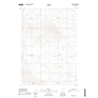
2017 Map of Rocky Butte
USGS Topo · Published 2017About this map
Rocky Butte stands as a prominent landmark in this section of Campbell County, presiding over a landscape defined by seasonal drainages and cattle country. The drainage network is anchored by Olmstead Cr and its various tributaries, including N Fork Olmstead Cr, which carve through the high plains. The map reveals the intricate natural topography of the Red Hills and Daley Draw, illustrating the complex erosion patterns characteristic of the Powder River Basin. Though settlement is sparse, the presence of Olmstead Rd and Bowers Ute Rd indicates the vital overland connections between remote ranching outposts. Water sources like Rock Cr and Coal Gulch reflect the geological and agricultural priorities of the region, where every named draw and creek served as a critical point of reference for early inhabitants and modern land managers alike.
Find a feature on this map
17 named features on this map. Tap any name to fly to it.
Don’t see what you’re looking for? This feature index may not catch every label — zoom into the map to look around manually.
Map Details
Editions of this 2017 Rocky Butte Map
This is the sole edition of this map. No revisions or reprints were ever made.
Other maps of this area

1954 · Ekalaka
USGS Topo · 1:250,000

1954 · Gillette
USGS Topo · 1:250,000

1955 · Gillette
USGS Topo · 1:250,000

1956 · Ekalaka
USGS Topo · 1:250,000

1958 · Gillette
USGS Topo · 1:250,000

1958 · Ekalaka
USGS Topo · 1:250,000

1962 · Gillette
USGS Topo · 1:250,000

1965 · Ekalaka
USGS Topo · 1:250,000

1970 · Wild Bill Creek
USGS Topo · 1:24,000
1970 · Biddle
USGS Topo · 1:24,000