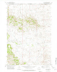
1972 Map of Rocky Butte
USGS Topo · Published 1975About this map
The Ute Oil Field dominates this early 1970s landscape along the border of Powder River and Campbell Counties. This part of the Powder River Basin shows a dense network of industrial infrastructure, characterized by numerous Drill Holes, Oil Wells, and pipelines that traverse the high plains. The rugged topography is defined by the striking Red Hills and the prominent landmark of Rocky Butte, which rises above the surrounding drainage systems of Olmstead Creek and its North Fork. Remote ranching or industrial aviation is evidenced by the presence of Landing Strips situated in the central portion of the quadrangle. Water sources are vital in this arid environment, with labels identifying various Wells, a Flowing Well, and several named seasonal drainages including Corral Creek, Rock Creek, and Coal Gulch, reflecting the region's geological and resource-based history.
Find a feature on this map
17 named features on this map. Tap any name to fly to it.
Don’t see what you’re looking for? This feature index may not catch every label — zoom into the map to look around manually.
Map Details
Editions of this 1972 Rocky Butte Map
This is the sole edition of this map. No revisions or reprints were ever made.
Other maps of this area

1954 · Ekalaka
USGS Topo · 1:250,000

1954 · Gillette
USGS Topo · 1:250,000

1955 · Gillette
USGS Topo · 1:250,000

1956 · Ekalaka
USGS Topo · 1:250,000

1958 · Gillette
USGS Topo · 1:250,000

1958 · Ekalaka
USGS Topo · 1:250,000

1962 · Gillette
USGS Topo · 1:250,000

1965 · Ekalaka
USGS Topo · 1:250,000

1970 · Wild Bill Creek
USGS Topo · 1:24,000
1970 · Biddle
USGS Topo · 1:24,000