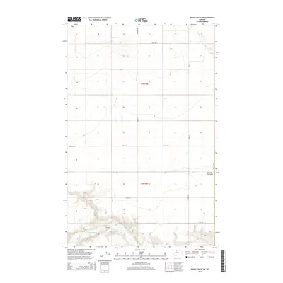
2014 Map of Rocky Coulee SW
USGS Topo · Published 2014About this map
The Marias River meanders through the southern portion of this high-plains landscape, cutting a deep valley into the topography of Hill Co. This 2014 survey illustrates the stark transition from the level agricultural lands of t30n r8e and t29n r8e to the complex drainage systems of Eightmile Coulee and Flat Coulee. A strict grid of section roads, including Inverness Rd and Road 55 S, organizes the landscape, reflecting the enduring legacy of the Public Land Survey System in Montana. Near the eastern boundary, Hansen Dr follows the edge of the coulees, marking the boundary between the elevated plains and the river breaks below. This map is particularly useful for understanding modern land division and rural infrastructure in this portion of the northern plains.
Find a feature on this map
19 named features on this map. Tap any name to fly to it.
Don’t see what you’re looking for? This feature index may not catch every label — zoom into the map to look around manually.
Map Details
Editions of this 2014 Rocky Coulee SW Map
This is the sole edition of this map. No revisions or reprints were ever made.
Other maps of this area

1954 · Shelby
USGS Topo · 1:250,000

1958 · Shelby
USGS Topo · 1:250,000

1969 · Dutch Henry Coulee
USGS Topo · 1:24,000
1969 · Discovery Butte
USGS Topo · 1:24,000

1970 · Poverty Coulee NE
USGS Topo · 1:24,000

1970 · Penzer School
USGS Topo · 1:24,000
1970 · Rocky Coulee SE
USGS Topo · 1:24,000

1970 · Poverty Coulee SE
USGS Topo · 1:24,000

1970 · Rocky Coulee SW
USGS Topo · 1:24,000

1970 · Rocky Coulee
USGS Topo · 1:24,000