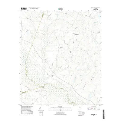
2017 Map of Rocky Ford
USGS Topo · Published 2017About this map
Rocky Ford and the surrounding Georgia countryside are defined by the winding course of the Ogeechee River, which forms the boundary line between Jenkins, Bulloch, and Screven Counties. This rural landscape is dotted with family-named landmarks and historical burial grounds such as Daughtry Cem, Finch Cem, and the Peggy Zeigler Cem Two, providing a clear map for genealogical research. Small settlements like Woodcliff, Thomasboro, and Parkers are connected by a network of local roads including Rocky Ford Rd and the E Old Savannah Rd. The terrain is characterized by a high concentration of wetlands and creeks, notably Little Horse Cr and Mile Br, which flow toward the river. Near the southern edge, Copps Bridge serves as a critical river crossing, while the Pegasus Ranch Airport indicates modern land use alongside these established agricultural and residential patterns.
Find a feature on this map
66 named features on this map. Tap any name to fly to it.
Don’t see what you’re looking for? This feature index may not catch every label — zoom into the map to look around manually.
Map Details
Editions of this 2017 Rocky Ford Map
This is the sole edition of this map. No revisions or reprints were ever made.
Other maps of this area

1918 · Oliver
USGS Topo · 1:62,500

1920 · Hilltonia
USGS Topo · 1:62,500

1920 · Millen
USGS Topo · 1:62,500

1920 · Oliver
USGS Topo · 1:62,500

1921 · Rocky Ford
USGS Topo · 1:62,500

1943 · Hilltonia
USGS Topo · 1:62,500

1943 · Rocky Ford
USGS Topo · 1:62,500

1943 · Millen
USGS Topo · 1:62,500

1943 · Millen
USGS Topo · 1:125,000

1943 · Oliver
USGS Topo · 1:62,500