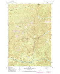
1964 Map of Rocky Point
USGS Topo · Published 1984About this map
Clearwater National Forest forms the backdrop for this mountain survey, which highlights the confluence of the Lochsa River and White Sand Creek. This remote Idaho territory is marked by significant forest management and early transit corridors, centered around the Powell Ranger Station and the nearby Lochsa Lodge. The map documents the historic Lolo Trail and various pack trails that crisscross the high ridges, including Parachute Trail and routes leading to Papoose Saddle. Strategic high-ground points like the Rocky Point Lookout and naming conventions such as 13 Mile Camp indicate the area's importance for fire observation and backcountry navigation. The landscape transitions from high-elevation points like Shotgun down to valley floor features such as Powell Pasture and Star Meadows, offering a view of the wilderness prior to modern road developments.
Find a feature on this map
30 named features on this map. Tap any name to fly to it.
Don’t see what you’re looking for? This feature index may not catch every label — zoom into the map to look around manually.
Map Details
Editions of this 1964 Rocky Point Map
2 editions found
Other maps of this area

1911 · Lolo
USGS Topo · 1:250,000

1913 · Lolo
USGS Topo · 1:250,000

1956 · Hamilton
USGS Topo · 1:250,000

1959 · Hamilton
USGS Topo · 1:250,000

1960 · Hamilton
USGS Topo · 1:250,000

1964 · Hamilton
USGS Topo · 1:250,000

1964 · Lolo Hot Springs
USGS Topo · 1:24,000

1964 · Rocky Point
USGS Topo · 1:24,000

1964 · Roundtop
USGS Topo · 1:24,000
1964 · Granite Pass
USGS Topo · 1:24,000