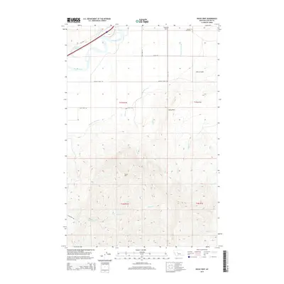
2014 Map of Rocky Reef
USGS Topo · Published 2014About this map
The Missouri River carves through the northern reaches of this landscape, its path accompanied by the Tintinger Slough and the wide, open expanse of Antelope Flat. This terrain is defined by the significant elevation change between the river valley and the heights of Harris Mtn and the namesake Rocky Reef prominence. The agricultural history of the region is evident in the extensive engineering of the Chestnut Valley Canal, which skirts the base of the hills to bring water to the lower fields near the community of Chestnut Valley. Local transit and settlement patterns are anchored by Old US 91 and the Chestnut Valley Cem, providing key points of interest for genealogists tracing families in this part of Cascade County. Numerous drainages such as Cherry Coulee, Sawmill Cr, and Bird Cr dissect the southern highlands, illustrating the complex watershed feeding into the Missouri.
Find a feature on this map
26 named features on this map. Tap any name to fly to it.
Don’t see what you’re looking for? This feature index may not catch every label — zoom into the map to look around manually.
Map Details
Editions of this 2014 Rocky Reef Map
This is the sole edition of this map. No revisions or reprints were ever made.
Other maps of this area

1886 · Great Falls
USGS Topo · 1:250,000

1949 · Cascade
USGS Topo · 1:62,500

1951 · Cascade
USGS Topo · 1:62,500

1954 · Great Falls
USGS Topo · 1:250,000

1957 · Great Falls
USGS Topo · 1:250,000

1960 · Simms
USGS Topo · 1:62,500

1961 · Hardy
USGS Topo · 1:24,000

1961 · Hound Creek Reservoir
USGS Topo · 1:24,000

1961 · Rocky Reef
USGS Topo · 1:24,000

1961 · Schrammeck Lake
USGS Topo · 1:24,000