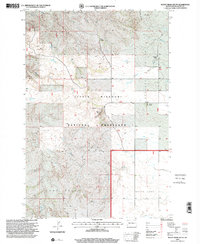
1997 Map of Rocky Ridge South
USGS Topo · Published 2001About this map
The Little Missouri National Grassland dominates this landscape in Slope County, where the sprawling public lands are interspersed with isolated private holdings. The region's economy and social structure are defined by established homesteads like Petri Ranch, Peterson Ranch, and Franklin Ranch, which sit alongside the drainages of Philbrick Creek and First Creek. Mineral extraction is evident in the northern portion of the quadrangle at the Uranium Pit, while scoria, a material often used for surfacing local ranch roads, is harvested at the Scoria Pit near Sand Creek. The terrain transitions from the high ground of Rocky Ridge down into the wide expanse of Peaceful Valley, where the Peterson Dam and White Lake provide essential water resources for cattle and wildlife in an otherwise semi-arid prairie environment.
Find a feature on this map
17 named features on this map. Tap any name to fly to it.
Don’t see what you’re looking for? This feature index may not catch every label — zoom into the map to look around manually.
Map Details
Editions of this 1997 Rocky Ridge South Map
This is the sole edition of this map. No revisions or reprints were ever made.
Other maps of this area

1953 · Dickinson
USGS Topo · 1:250,000

1957 · Dickinson
USGS Topo · 1:250,000

1961 · Daglum
USGS Topo · 1:62,500

1961 · Rocky Ridge
USGS Topo · 1:62,500

1973 · Black Butte
USGS Topo · 1:24,000

1973 · White Lake
USGS Topo · 1:24,000

1973 · Amidon
USGS Topo · 1:24,000

1980 · Belfield
USGS Topo · 1:100,000

1981 · Bowman
USGS Topo · 1:100,000
1982 · Daglum NW
USGS Topo · 1:24,000