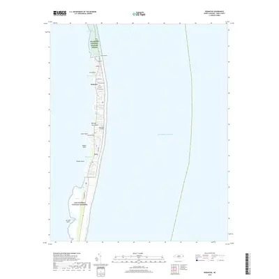
2019 Map of Rodanthe
USGS Topo · Published 2019About this map
Hatteras Island dominates this 2019 survey, illustrating the fragile landforms of the Outer Banks between the Atlantic Ocean and the inner sounds. The map traces the Tri-Villages of Rodanthe, Waves, and Salvo, where residential streets like Sea-Haven Dr and Sudie Payne Rd are concentrated along the narrow ribbon of land. To the north, the Pea Island National Wildlife Refuge preserves the landscape of Pea Island, while the southern reaches fall within the Cape Hatteras National Seashore. This documentation of the shoreline reveals the intricate marshlands and points on the sound side, including Aunt Phoebes Marsh, Midgett Cove, and Davids Point. The presence of features like Wimble Shoals and the shifting channels around No Ache Island underscore the dynamic maritime environment that defines this thin barrier island chain.
Find a feature on this map
31 named features on this map. Tap any name to fly to it.
Don’t see what you’re looking for? This feature index may not catch every label — zoom into the map to look around manually.
Map Details
Editions of this 2019 Rodanthe Map
This is the sole edition of this map. No revisions or reprints were ever made.
Other maps of this area

1943 · Roanoke Island
USGS Topo · 1:125,000

1955 · Wanchese
USGS Topo · 1:250,000

1957 · Manteo
USGS Topo · 1:250,000

1960 · Manteo
USGS Topo · 1:250,000

1985 · Cape Hatteras
USGS Topo · 1:100,000

1985 · Manteo
USGS Topo · 1:100,000
2011 · Gull Island
USGS Topo · 1:24,000
2011 · Pea Island OE W
USGS Topo · 1:24,000
2011 · Pea Island
USGS Topo · 1:24,000
2011 · Little Kinnakeet
USGS Topo · 1:24,000