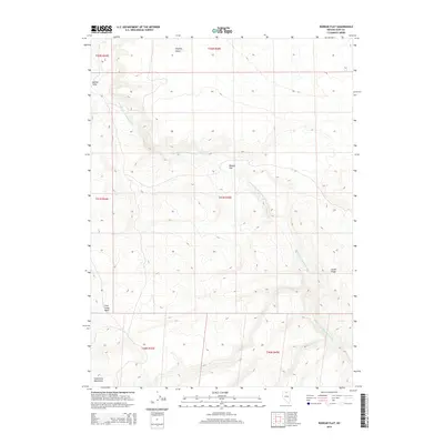
2015 Map of Rodear Flat
USGS Topo · Published 2015About this map
The S Fork Little Humboldt River carves through this corner of Elko County, following a winding course between the northern reaches of the Snowstorm Mountains and the arid expanse of the Owyhee Desert. This 2015 survey reveals a high-desert landscape defined by elevation and drainage, where the river serves as the primary corridor through the terrain. To the east, Castle Ridge overlooks the valley floor, while the central plateau is occupied by the eponymous Rodear Flat. The mapping reflects a region dominated by large-scale geographical features rather than dense settlement, with only localized landmarks such as Button Field and the First Creek Basin providing human-scale reference points. It is a portrait of the Great Basin's interior, showing how the intermittent flows of First Cr and Snowstorm Cr contribute to the hydrologic network of this remote Nevada quadrangle.
Find a feature on this map
15 named features on this map. Tap any name to fly to it.
Don’t see what you’re looking for? This feature index may not catch every label — zoom into the map to look around manually.
Map Details
Editions of this 2015 Rodear Flat Map
This is the sole edition of this map. No revisions or reprints were ever made.
Other maps of this area

1882 · Paradise
USGS Topo · 1:250,000

1893 · Paradise
USGS Topo · 1:250,000

1955 · McDermitt
USGS Topo · 1:250,000

1959 · McDermitt
USGS Topo · 1:250,000

1973 · Snowstorm Mtn
USGS Topo · 1:24,000
1973 · Rodear Flat
USGS Topo · 1:24,000

1973 · McCleary Wells
USGS Topo · 1:24,000

1973 · Haystack Peak
USGS Topo · 1:24,000

1973 · Humboldt Hill
USGS Topo · 1:24,000
1977 · Oregon Canyon
USGS Topo · 1:24,000