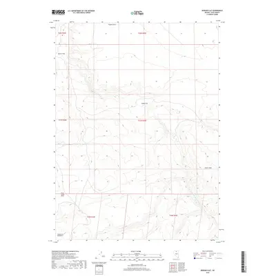
2018 Map of Rodear Flat
USGS Topo · Published 2018About this map
Owyhee Desert terrain dominates this northern Elko County landscape, where high-desert plains meet the rising slopes of the Snowstorm Mountains. The 2018 survey detail centers on Rodear Flat, a geographic depression positioned between the expansive desert and the more complex topography of the First Creek Basin to the southwest. This area serves as a significant drainage point for the S Fork Little Humboldt River, which meanders through the southeastern portion of the quadrangle. The map reveals the relationship between low-lying catchment areas like Button Field and the prominent volcanic or tectonic features such as Castle Ridge. This is a largely uninhabited landscape defined by the Public Land Survey System grid, which divides the vast open ranges of the Great Basin into distinct townships and ranges.
Find a feature on this map
13 named features on this map. Tap any name to fly to it.
Don’t see what you’re looking for? This feature index may not catch every label — zoom into the map to look around manually.
Map Details
Editions of this 2018 Rodear Flat Map
This is the sole edition of this map. No revisions or reprints were ever made.
Other maps of this area

1882 · Paradise
USGS Topo · 1:250,000

1893 · Paradise
USGS Topo · 1:250,000

1955 · McDermitt
USGS Topo · 1:250,000

1959 · McDermitt
USGS Topo · 1:250,000

1973 · Snowstorm Mtn
USGS Topo · 1:24,000
1973 · Rodear Flat
USGS Topo · 1:24,000

1973 · McCleary Wells
USGS Topo · 1:24,000

1973 · Haystack Peak
USGS Topo · 1:24,000

1973 · Humboldt Hill
USGS Topo · 1:24,000
1977 · Oregon Canyon
USGS Topo · 1:24,000