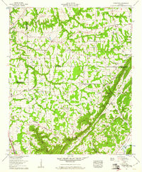
1959 Map of Rodentown
USGS Topo · Published 1960About this map
Sand Mountain and the sharp descent of the Tennessee Valley Divide define the landscape across the borders of Etowah, DeKalb, and Marshall Counties. Small agrarian communities and school sites like the Center Point Sch and the Smith Institute reflect the rural settlement patterns of northern Alabama in the mid-20th century. The topography is split between the high plateau and the lowland valleys of Dugout Valley and the Tennessee Valley, connected by narrow passes such as Horton Gap, Belcher Gap, and Leath Gap. Local travel during this era relied on historic routes like the Georgia Road and its earlier alignment, the Old Georgia Road. The map also documents numerous country churches and family burial grounds, including Bethlehem Ch and the Sardis Cem, providing a detailed view of the social and genealogical fabric of these interconnected ridge-and-valley communities.
Find a feature on this map
59 named features on this map. Tap any name to fly to it.
Don’t see what you’re looking for? This feature index may not catch every label — zoom into the map to look around manually.
Map Details
Editions of this 1959 Rodentown Map
4 editions found
Other maps of this area

1885 · Gadsden
USGS Topo · 1:125,000

1888 · Gadsden
USGS Topo · 1:125,000

1892 · Gadsden
USGS Topo · 1:125,000

1893 · Fort Payne
USGS Topo · 1:125,000

1895 · Gadsden
USGS Topo · 1:125,000

1898 · Fort Payne
USGS Topo · 1:125,000

1900 · Fort Payne
USGS Topo · 1:125,000

1903 · Gadsden
USGS Topo · 1:125,000

1936 · Painter
USGS Topo · 1:24,000

1936 · Crossville
USGS Topo · 1:24,000