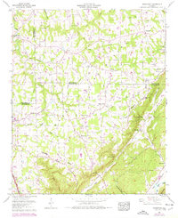
1959 Map of Rodentown
USGS Topo · Published 1976About this map
Sand Mountain dominates this landscape, its plateau surface marked by a network of rural settlements and family-named churches. This 1959 survey, updated with 1974 photorevisions, reveals a community structure centered around small nodes like Rodentown, Painter, and Whitesboro. The terrain is deeply divided by the descent from the mountain into Little Sand Valley and Big Wills Valley, connected by local thoroughfares such as Georgia Road and the Old Tennessee Valley Road.
Find a feature on this map
65 named features on this map. Tap any name to fly to it.
Don’t see what you’re looking for? This feature index may not catch every label — zoom into the map to look around manually.
Map Details
Editions of this 1959 Rodentown Map
4 editions found
Other maps of this area

1885 · Gadsden
USGS Topo · 1:125,000

1888 · Gadsden
USGS Topo · 1:125,000

1892 · Gadsden
USGS Topo · 1:125,000

1893 · Fort Payne
USGS Topo · 1:125,000

1895 · Gadsden
USGS Topo · 1:125,000

1898 · Fort Payne
USGS Topo · 1:125,000

1900 · Fort Payne
USGS Topo · 1:125,000

1903 · Gadsden
USGS Topo · 1:125,000

1936 · Painter
USGS Topo · 1:24,000

1936 · Crossville
USGS Topo · 1:24,000