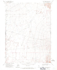
1968 Map of Rodeo Creek SW
USGS Topo · Published 1971About this map
Boulder Valley dominates this high-desert landscape in northern Nevada, characterized by its arid expanse and essential water infrastructure for ranching. The 1968 field survey documents a network of critical landmarks, including the T Lazy S Farm and several specialized water sources like the Sand Dune Windmill and Alkali Windmill. These features indicate the agricultural and livestock-focused economy of the region during the late 1960s.
Find a feature on this map
15 named features on this map. Tap any name to fly to it.
Don’t see what you’re looking for? This feature index may not catch every label — zoom into the map to look around manually.
Map Details
Editions of this 1968 Rodeo Creek SW Map
2 editions found
Other maps of this area

1955 · Winnemucca
USGS Topo · 1:250,000

1957 · Dunphy
USGS Topo · 1:62,500

1957 · Beowawe
USGS Topo · 1:62,500

1958 · Winnemucca
USGS Topo · 1:250,000

1962 · Winnemucca
USGS Topo · 1:250,000

1965 · Sheep Creek Range NE
USGS Topo · 1:24,000

1965 · Sheep Creek Range SE
USGS Topo · 1:24,000

1968 · Rodeo Creek SW
USGS Topo · 1:24,000

1968 · Rodeo Creek NE
USGS Topo · 1:24,000

1968 · Welches Canyon
USGS Topo · 1:24,000