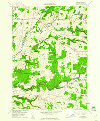
1959 Map of Rodman
USGS Topo · Published 1961About this map
Sandy Creek and the North Branch Sandy Creek carve through the agricultural landscape of south-central Jefferson County, defining a region where small hamlets like Rodman and Lorraine serve as local hubs. The terrain is marked by dramatic geological features known as gulfs, including Washington Gulf, Towle Gulf, and Fox Gulf, which slice through the plateau south of the State Reforestation Area. This 1959 survey records a network of established family-named crossroads such as Whitford Corners, Ross Corners, and Tremaines Corners, reflecting the persistent settlement patterns of northern New York. Genealogists will find several burial grounds noted, from the Honeyville Cem in the northwest to the Lyman Cem in the southwest, while the presence of a Quarry and a local Airstrip near Zoar point to the area's mid-century rural utility.
Find a feature on this map
65 named features on this map. Tap any name to fly to it.
Don’t see what you’re looking for? This feature index may not catch every label — zoom into the map to look around manually.
Map Details
Editions of this 1959 Rodman Map
3 editions found
Other maps of this area

1893 · Sackets Harbor
USGS Topo · 1:62,500

1895 · Sacketts Harbor
USGS Topo · 1:62,500

1895 · Pulaski
USGS Topo · 1:62,500

1895 · Watertown
USGS Topo · 1:62,500

1898 · Watertown
USGS Topo · 1:62,500

1903 · Orwell
USGS Topo · 1:62,500

1905 · Orwell
USGS Topo · 1:62,500

1908 · Watertown
USGS Topo · 1:62,500

1909 · Watertown
USGS Topo · 1:62,500

1942 · Sandy Creek
USGS Topo · 1:24,000