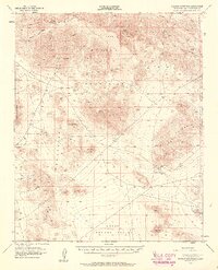
1955 Map of Rodman Mountains
USGS Topo · Published 1961About this map
Rodman Mountains and the surrounding high desert of San Bernardino County are defined here by a mid-century landscape of extraction and ancient history. The terrain is marked by significant mining operations, including the Camp Rock Mine, Bessemer Mine, and Silver Bell Mine, alongside numerous unnamed shafts and prospects that suggest a period of active exploration. In the lower elevations, Upper Johnson Valley transitions into the southern reaches of the Marine Corps Training Center. Cultural heritage is preserved through a label for Indian Petroglyphs located within a field of lava, while survival in this arid environment is tied to water sources like Kane Springs and Sheep Spring. A remote Landing Field near the Bessemer Mine further illustrates the era's reliance on air and primitive road access to reach these mountain ranges.
Find a feature on this map
23 named features on this map. Tap any name to fly to it.
Don’t see what you’re looking for? This feature index may not catch every label — zoom into the map to look around manually.
Map Details
Editions of this 1955 Rodman Mountains Map
3 editions found

Other maps of this area

1901 · Southern California Sheet No. 1
USGS Topo · 1:250,000

1902 · San Gorgonio
USGS Topo · 1:125,000

1904 · Southern California Sheet No. 1
USGS Topo · 1:250,000

1947 · Lucerne Valley
USGS Topo · 1:62,500

1949 · Lucerne Valley
USGS Topo · 1:62,500

1953 · San Bernardino
USGS Topo · 1:250,000

1954 · Galway Lake
USGS Topo · 1:24,000

1954 · Emerson Lake
USGS Topo · 1:24,000

1955 · Silver Bell Mine
USGS Topo · 1:24,000

1955 · Sunshine Peak
USGS Topo · 1:24,000