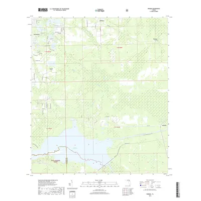
2018 Map of Rodman
USGS Topo · Published 2018About this map
Lake Ocklawaha dominates the southern landscape, marking a significant hydrological feature where the Ocklawaha River meets the Cross-Florida Barge Canal. This area of Putnam County is characterized by a dense network of water bodies and wetlands, ranging from the northern cluster of Twin Lakes and Hasenjaeger Lake near Interlachen to the vast swampy stretches of The Slash and Cow Heaven Bay. The northern portion of the Ocala National Forest extends into the southwest corner, preserving the natural character of the terrain near Blue Springs. Settlement patterns follow the higher ground between these aquatic systems, with the community of Hollister situated along the northern corridor and the historic settlement of Rodman positioned near the canal's eastern reach. A intricate web of named rural tracks like Possum Walk Rd and Hollister Cemetery Rd provides access to these forested and lakeside reaches, reflecting a region deeply tied to its wetlands and protected timberlands.
Find a feature on this map
66 named features on this map. Tap any name to fly to it.
Don’t see what you’re looking for? This feature index may not catch every label — zoom into the map to look around manually.
Map Details
Editions of this 2018 Rodman Map
This is the sole edition of this map. No revisions or reprints were ever made.
Other maps of this area

1912 · Palatka
USGS Topo · 1:48,000

1915 · Palatka
USGS Topo · 1:62,500

1915 · Interlachen
USGS Topo · 1:48,000

1916 · Interlachen
USGS Topo · 1:62,500

1944 · Interlachen
USGS Topo · 1:62,500

1949 · Keuka
USGS Topo · 1:24,000

1949 · Baywood
USGS Topo · 1:24,000

1949 · Rodman
USGS Topo · 1:24,000
1949 · Putnam Hall
USGS Topo · 1:24,000

1949 · Interlachen
USGS Topo · 1:62,500