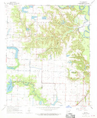
1968 Map of Roe
USGS Topo · Published 1970About this map
The St Louis Southwestern railroad tracks anchor the small community of Roe in this late 1960s survey of the Arkansas Delta. The landscape is a transition between the organized agriculture of the Grand Prairie and the dense, swampy bottoms of the White River floodplain. Large protected tracts like Wattensaw and Roc Roe dominate the central and eastern portions of the sheet, where Honey Creek and Washington Creek carve through the terrain toward the river. To the west, the extensive waters of Peckerwood Lake and Peckwood Lake illustrate the vital role of irrigation and water management in this rice-growing region. Rural life is marked by several neighborhood congregations, including Peppers Lake Ch and Hurricane Ch, while the Clarendon Airport and a separate Landing Strip reflect the era's reliance on crop dusting and local aviation.
Find a feature on this map
27 named features on this map. Tap any name to fly to it.
Don’t see what you’re looking for? This feature index may not catch every label — zoom into the map to look around manually.
Map Details
Editions of this 1968 Roe Map
This is the sole edition of this map. No revisions or reprints were ever made.
Other maps of this area

1935 · Hazen
USGS Topo · 1:62,500

1935 · Clarendon
USGS Topo · 1:62,500

1937 · Stuttgart
USGS Topo · 1:62,500

1939 · Stuttgart
USGS Topo · 1:62,500

1941 · Hazen
USGS Topo · 1:62,500

1941 · De Valls Bluff
USGS Topo · 1:62,500

1941 · Clarendon
USGS Topo · 1:62,500

1948 · Helena
USGS Topo · 1:250,000

1950 · Helena
USGS Topo · 1:250,000

1955 · Helena
USGS Topo · 1:250,000