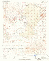
1956 Map of Rogers Lake
USGS Topo · Published 1957About this map
Air Force Flight Test Center operations dominate this mid-century landscape in the High Desert, showing the infrastructure of early supersonic and aerospace testing. The vast, flat expanse of Rogers Lake serves as the natural foundation for the Edwards Air Force Base complex, including the North Base and South Base. Residential life for military families is centered at Wherry Housing, supported by Desert High Sch and nearby community markers like the Joshua Tree Grange. Outside the high-tech corridors of the base and its Test Track, the map traces the legacy of earlier eras through the Old Railroad Grade and small settlements like Muroc and Bissell. The transition from the Bissell Hills to the desert floor is bisected by the Kern Co Los Angeles Co line, where the arid landscape is gridded by a network of lettered roads such as Avenue A and Avenue F.
Find a feature on this map
40 named features on this map. Tap any name to fly to it.
Don’t see what you’re looking for? This feature index may not catch every label — zoom into the map to look around manually.
Map Details
Editions of this 1956 Rogers Lake Map
2 editions found
Other maps of this area

1915 · Elizabeth Lake
USGS Topo · 1:125,000

1915 · Searles Lake
USGS Topo · 1:250,000

1915 · Mojave
USGS Topo · 1:125,000

1917 · Elizabeth Lake
USGS Topo · 1:125,000

1930 · Joshua
USGS Topo · 1:24,000

1930 · Roosevelt School
USGS Topo · 1:24,000

1930 · Casa Desierta
USGS Topo · 1:24,000

1931 · Hi Vista
USGS Topo · 1:24,000

1933 · Casa Desierta
USGS Topo · 1:24,000

1933 · Roosevelt School
USGS Topo · 1:24,000