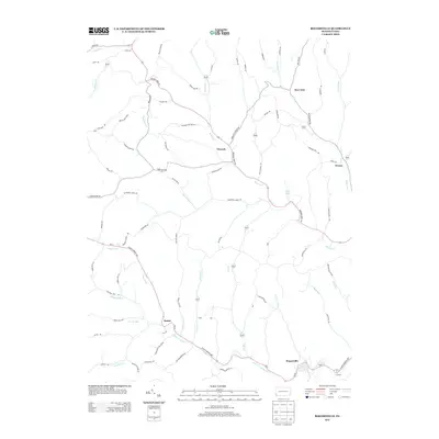
2013 Map of Rogersville
USGS Topo · Published 2013About this map
Nineveh sits at the junction of Browns Cr and several rural ridges, anchoring a landscape defined by narrow valleys and deep hollows. This portion of Washington County is characterized by a dense network of country lanes, including Deerlick Station Rd and WW Railroad Rd, which trace the path of earlier transportation corridors. In the southern reach of the map, the community of Rogersville lies along the S Fork Tenmile Cr, where local landmarks like Norman Hollow and Muddy Hollow meet the creek's winding course. Genealogists and local historians can trace family-named features such as Devils Half Acre and Swarts Hl or find the small settlements of Rutan and Deer Lick. The terrain is marked by significant ridges like Hopewell Ridge and Beulah Ridge, illustrating the traditional Appalachian settlement patterns where homesteads followed the fertile bottomlands and accessible gaps.
Find a feature on this map
82 named features on this map. Tap any name to fly to it.
Don’t see what you’re looking for? This feature index may not catch every label — zoom into the map to look around manually.
Map Details
Editions of this 2013 Rogersville Map
This is the sole edition of this map. No revisions or reprints were ever made.
Other maps of this area

1901 · Amity
USGS Topo · 1:62,500

1901 · Waynesburg
USGS Topo · 1:62,500

1904 · Amity
USGS Topo · 1:62,500

1904 · Waynesburg
USGS Topo · 1:62,500

1905 · Rogersville
USGS Topo · 1:62,500

1907 · Claysville
USGS Topo · 1:62,500

1949 · Clarksburg
USGS Topo · 1:250,000

1951 · Canton
USGS Topo · 1:250,000

1953 · Canton
USGS Topo · 1:250,000
1954 · Amity
USGS Topo · 1:24,000