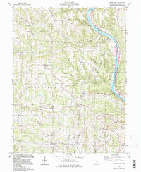
1994 Map of Rokeby Lock
USGS Topo · Published 1998About this map
The Muskingum River flows through this corner of Morgan County, shaping the local geography from the namesake Rokeby Lock down past the Drivein Theater on the riverbank. This 1994 update of mid-century topography reveals a landscape where extractive industry and rural life intersect, featuring an active Oil Field and scattered Gas Wells tucked into the steep hollows. The terrain is marked by numerous family-named cemeteries such as Albright Cem, Dutch Hill Cem, and Wiseman Cem, providing valuable anchors for genealogical research in small settlements like Eagleport and Triadelphia.
Find a feature on this map
44 named features on this map. Tap any name to fly to it.
Don’t see what you’re looking for? This feature index may not catch every label — zoom into the map to look around manually.
Map Details
Editions of this 1994 Rokeby Lock Map
This is the sole edition of this map. No revisions or reprints were ever made.
Other maps of this area

1910 · Philo
USGS Topo · 1:62,500

1910 · Zanesville
USGS Topo · 1:62,500

1910 · Mc Connelsville
USGS Topo · 1:62,500

1911 · New Lexington
USGS Topo · 1:62,500

1947 · Columbus
USGS Topo · 1:250,000

1949 · Clarksburg
USGS Topo · 1:250,000

1956 · Clarksburg
USGS Topo · 1:250,000

1961 · Columbus
USGS Topo · 1:250,000

1961 · Clarksburg
USGS Topo · 1:250,000

1961 · Mc Connelsville
USGS Topo · 1:24,000