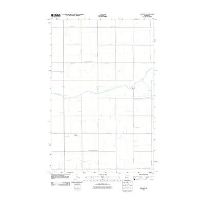
2010 Map of Roland
USGS Topo · Published 2010About this map
Roland sits at the junction of County Hwy-10 and County Hwy-127 in this corner of Red Lake County, where the meandering Clearwater River cuts through an extensively engineered agricultural landscape. The township structure is defined by a rigorous grid of section lines and county highways, including County Hwy-1 and County Hwy-134. This 2010 survey illustrates the sophisticated drainage network essential to local farming, marked by significant waterways like Judicial Ditch Number One, Judicial Ditch Number Three, and County Ditch Number Fiftyeight. Near the intersection of several section roads, the Salem Cemetery remains a quiet landmark of the community's genealogy. The map captures a moment in the early 21st century where traditional rural settlements and modern water management systems intersect across the Minnesota plains.
Find a feature on this map
21 named features on this map. Tap any name to fly to it.
Don’t see what you’re looking for? This feature index may not catch every label — zoom into the map to look around manually.
Map Details
Editions of this 2010 Roland Map
This is the sole edition of this map. No revisions or reprints were ever made.
Other maps of this area

1919 · Grit
USGS Topo · 1:62,500

1919 · Winsor
USGS Topo · 1:62,500

1954 · Bemidji
USGS Topo · 1:250,000

1954 · Roseau
USGS Topo · 1:250,000

1957 · Roseau
USGS Topo · 1:250,000

1957 · Bemidji
USGS Topo · 1:250,000

1958 · Bemidji
USGS Topo · 1:250,000

1958 · Roseau
USGS Topo · 1:250,000
1971 · Oklee
USGS Topo · 1:24,000
1971 · Roland
USGS Topo · 1:24,000