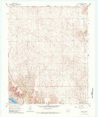
1965 Map of Roll NW
USGS Topo · Published 1984About this map
The Canadian River cuts through the southwestern corner of this mid-1960s landscape, marking a distinct boundary between Ellis and Roger Mills Counties. This high-plains terrain is characterized by the wide, sandy channels of the river and the northern Sand Creek, where drainage patterns define the local geography. Human industry is sparse but present, noted by a lone Oil Well and a Drill Hole, signifying the early stages of resource exploration in this region. The water levels of Packsaddle Lake provide a rare stationary water feature in an otherwise arid expanse. The map illustrates a transitional period in Western Oklahoma, where traditional ranching land began to see the quiet introduction of petroleum infrastructure alongside permanent water catchments.
Find a feature on this map
9 named features on this map. Tap any name to fly to it.
Don’t see what you’re looking for? This feature index may not catch every label — zoom into the map to look around manually.
Map Details
Editions of this 1965 Roll NW Map
2 editions found
Other maps of this area

1955 · Clinton
USGS Topo · 1:250,000

1955 · Woodward
USGS Topo · 1:250,000

1957 · Clinton
USGS Topo · 1:250,000

1958 · Woodward
USGS Topo · 1:250,000

1965 · Roll NE
USGS Topo · 1:24,000

1965 · Roll NW
USGS Topo · 1:24,000

1965 · Crawford
USGS Topo · 1:24,000

1966 · Roll
USGS Topo · 1:24,000

1966 · Antelope Hills NE
USGS Topo · 1:24,000

1966 · Roll SE
USGS Topo · 1:24,000