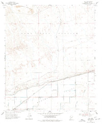
1955 Map of Roll
USGS Topo · Published 1977About this map
The Mohawk Valley in the mid-1950s was a landscape defined by an intensive irrigation network and military activity. The Gila River provides the natural foundation for the valley, but the presence of the Mohawk Canal and the Southern Pacific Canal reveals the sophisticated water management required to support the local agricultural community. To the north, the terrain transitions into the desolate reaches of the Yuma Test Station and the rising peaks of the Castle Dome Mts. Local infrastructure and settlement patterns are concentrated around the village of Roll, which serves as a hub for the surrounding area. The presence of the Mohawk Valley Sch and Terry Ranch indicates a established ranching and farming society, while numerous features like Salt Well and various Gravel Pit sites show the practical use of the arid land.
Find a feature on this map
15 named features on this map. Tap any name to fly to it.
Don’t see what you’re looking for? This feature index may not catch every label — zoom into the map to look around manually.
Map Details
Editions of this 1955 Roll Map
3 editions found
Other maps of this area

1926 · Wellton
USGS Topo · 1:62,500

1926 · Mohawk
USGS Topo · 1:62,500

1928 · Mohawk
USGS Topo · 1:62,500

1928 · Norton
USGS Topo · 1:62,500

1929 · Wellton
USGS Topo · 1:62,500

1929 · Norton
USGS Topo · 1:62,500

1942 · Yuma
USGS Topo · 1:250,000

1953 · Ajo
USGS Topo · 1:250,000

1954 · El Centro
USGS Topo · 1:250,000

1955 · El Centro
USGS Topo · 1:250,000