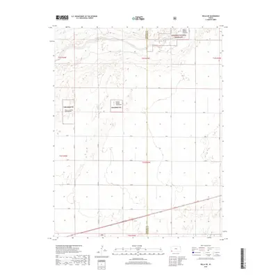
2018 Map of Rolla NE
USGS Topo · Published 2018About this map
The Cimarron River winds through the northern portion of this High Plains landscape, marking a distinct break in the otherwise orderly grid of Section Line roads. This 2018 survey captures the interface between the Cimarron National Grassland and the surrounding agricultural tracts in Stevens County. Large tracts of protected land are identified by specific administrative units, including Pasture Number Fortyfour, Pasture Number Twentyfour, and Pasture Number Twentythree. These numbered pastures reflect the managed grazing system unique to the National Grasslands. The southern region of the map is defined by a rigorous network of rural thoroughfares such as L Blvd and Rd M, which organize the territory into the standard townships of the Public Land Survey System, illustrating the enduring geometry of Kansas land division.
Find a feature on this map
24 named features on this map. Tap any name to fly to it.
Don’t see what you’re looking for? This feature index may not catch every label — zoom into the map to look around manually.
Map Details
Editions of this 2018 Rolla NE Map
This is the sole edition of this map. No revisions or reprints were ever made.
Other maps of this area

1955 · Dodge City
USGS Topo · 1:250,000

1958 · Dodge City
USGS Topo · 1:250,000

1959 · Dodge City
USGS Topo · 1:250,000

1973 · Shore Airport SW
USGS Topo · 1:24,000

1973 · Rolla NW
USGS Topo · 1:24,000

1973 · Rolla NE
USGS Topo · 1:24,000
1974 · Rolla SE
USGS Topo · 1:24,000

1974 · Feterita
USGS Topo · 1:24,000
1974 · Hugoton SW
USGS Topo · 1:24,000

1974 · Shore Airport SE
USGS Topo · 1:24,000