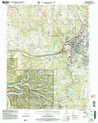
2004 Map of Rolla
USGS Topo · Published 2006About this map
Rolla serves as a significant regional hub in the early 2000s, anchored by the Univ of Missouri-Rolla and surrounded by a landscape that balances industrial activity with conservation. The town is flanked by heavy infrastructure, including the Burlington Northern Santa Fe railway and the Rolla Downtown Airport, while the western edge transitions into the protected hills of the Mark Twain National Forest. Local heritage is preserved in numerous family and community burial grounds, such as Pea Ridge Cem and Hoss-Ray-Miller Cem, dotting the rural areas outside of Northwye.
Find a feature on this map
66 named features on this map. Tap any name to fly to it.
Don’t see what you’re looking for? This feature index may not catch every label — zoom into the map to look around manually.
Map Details
Editions of this 2004 Rolla Map
This is the sole edition of this map. No revisions or reprints were ever made.
Other maps of this area

1912 · Rolla
USGS Topo · 1:62,500

1928 · Meramec Spring
USGS Topo · 1:62,500

1934 · Redbird
USGS Topo · 1:62,500

1937 · Vienna
USGS Topo · 1:62,500

1938 · Redbird
USGS Topo · 1:62,500

1938 · Vienna
USGS Topo · 1:48,000

1949 · Saint Louis
USGS Topo · 1:250,000

1949 · Vienna
USGS Topo · 1:62,500

1949 · Rolla
USGS Topo · 1:250,000

1949 · Meramec Spring
USGS Topo · 1:62,500