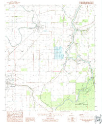
1988 Map of Rolling Fork East
USGS Topo · Published 1988About this map
The low-lying Yazoo Basin floodplain is defined here by the winding Big Sunflower River and its intricate network of bayous. In the 1980s, the landscape around the town of Anguilla and the settlement of Africa was dominated by agricultural fields, punctuated by numerous Cemeteries and infrastructure like a Landing Strip and Sewage Lagoon. The area's water management is evident in the Spoil Banks and floodgates scattered along the waterways, particularly where the river borders the Delta National Forest.
Find a feature on this map
38 named features on this map. Tap any name to fly to it.
Don’t see what you’re looking for? This feature index may not catch every label — zoom into the map to look around manually.
Map Details
Editions of this 1988 Rolling Fork East Map
This is the sole edition of this map. No revisions or reprints were ever made.
Other maps of this area

1939 · Lorenzen
USGS Topo · 1:62,500

1939 · Swan Lake
USGS Topo · 1:62,500

1940 · Auter
USGS Topo · 1:62,500

1953 · Greenwood
USGS Topo · 1:250,000

1955 · Jackson
USGS Topo · 1:250,000

1956 · Greenwood
USGS Topo · 1:250,000

1961 · Jackson
USGS Topo · 1:250,000

1961 · Bayland
USGS Topo · 1:62,500

1962 · Jackson
USGS Topo · 1:250,000

1964 · Lorenzen
USGS Topo · 1:62,500