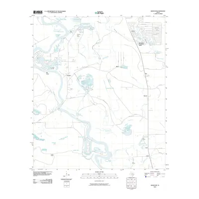
2010 Map of Romayor
USGS Topo · Published 2010About this map
The Trinity River snakes through this portion of Liberty County, shaping a landscape of oxbow lakes and wetlands like Horseshoe Lake, New River Lake, and Oneal Lake. The settlement of Romayor sits near the riverbanks, serving as a focal point for the surrounding rural communities of Milvid, Rye, and Marvels. This environment is defined by its complex hydrology, where Menard Creek and Big Creek feed into the larger river system, creating numerous ponds and breaks such as McAnally Break.
Find a feature on this map
79 named features on this map. Tap any name to fly to it.
Don’t see what you’re looking for? This feature index may not catch every label — zoom into the map to look around manually.
Map Details
Editions of this 2010 Romayor Map
This is the sole edition of this map. No revisions or reprints were ever made.
Other maps of this area

1943 · Liberty
USGS Topo · 1:125,000

1954 · Beaumont
USGS Topo · 1:250,000

1955 · Saratoga
USGS Topo · 1:62,500

1955 · Rayburn
USGS Topo · 1:62,500

1957 · Beaumont
USGS Topo · 1:250,000

1958 · Livingston
USGS Topo · 1:62,500

1958 · Segno
USGS Topo · 1:62,500

1984 · Segno
USGS Topo · 1:24,000

1984 · Beaumont
USGS Topo · 1:250,000
1984 · Goodrich
USGS Topo · 1:24,000