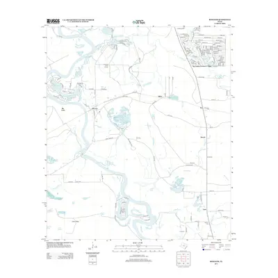
2013 Map of Romayor
USGS Topo · Published 2013About this map
The Trinity River snakes through this portion of Liberty County, defining a landscape of oxbow lakes, bayous, and dense bottomlands. Small settlements and residential clusters such as Romayor and Milvid are scattered across the terrain, while the northeast corner shows the concentrated development of Big Thicket Creekmore Village. The area is marked by a complex network of waterways including Fields Bayou and Nevill Bayou, which feed into various bodies of water like Hardwood Lake and Ward Prairie Lakes. Genealogists will find several family-named burial sites, including Hank Cem, McNulty Cem, and Fields Cem, primarily located on the eastern side of the river. Aviation history is noted by the presence of the F R Duke Farm Airport situated near a bend in the river, reflecting the rural and private transport infrastructure of this East Texas region.
Find a feature on this map
119 named features on this map. Tap any name to fly to it.
Don’t see what you’re looking for? This feature index may not catch every label — zoom into the map to look around manually.
Map Details
Editions of this 2013 Romayor Map
This is the sole edition of this map. No revisions or reprints were ever made.
Other maps of this area

1943 · Liberty
USGS Topo · 1:125,000

1954 · Beaumont
USGS Topo · 1:250,000

1955 · Saratoga
USGS Topo · 1:62,500

1955 · Rayburn
USGS Topo · 1:62,500

1957 · Beaumont
USGS Topo · 1:250,000

1958 · Livingston
USGS Topo · 1:62,500

1958 · Segno
USGS Topo · 1:62,500

1984 · Segno
USGS Topo · 1:24,000

1984 · Beaumont
USGS Topo · 1:250,000
1984 · Goodrich
USGS Topo · 1:24,000