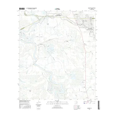
2016 Map of Romayor
USGS Topo · Published 2016About this map
The Trinity River dominates this portion of the Texas Gulf Coastal Plain, winding through a complex network of oxbow lakes and wetlands near the Liberty, Polk, and San Jacinto county lines. The landscape is defined by the expansive Big Thicket National Preserve, where water features like Chain O'Lakes, Horseshoe Lake, and Wild Cow Marsh illustrate the area's rich ecological diversity. Small settlements such as Romayor, Milvid, and Rye are scattered across the terrain, connected by farm roads like FM 2610 and FM 787 W. Local history is anchored by family and community landmarks, including Hank Cem, McNulty Cem, and Fields Cem. The map provides a detailed view of the interaction between the river's shifting path, seen in features like New River Lake and Coon Slough, and the rural infrastructure of the early 21st century.
Find a feature on this map
128 named features on this map. Tap any name to fly to it.
Don’t see what you’re looking for? This feature index may not catch every label — zoom into the map to look around manually.
Map Details
Editions of this 2016 Romayor Map
This is the sole edition of this map. No revisions or reprints were ever made.
Other maps of this area

1943 · Liberty
USGS Topo · 1:125,000

1954 · Beaumont
USGS Topo · 1:250,000

1955 · Saratoga
USGS Topo · 1:62,500

1955 · Rayburn
USGS Topo · 1:62,500

1957 · Beaumont
USGS Topo · 1:250,000

1958 · Livingston
USGS Topo · 1:62,500

1958 · Segno
USGS Topo · 1:62,500

1984 · Segno
USGS Topo · 1:24,000

1984 · Beaumont
USGS Topo · 1:250,000
1984 · Goodrich
USGS Topo · 1:24,000