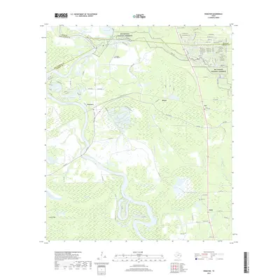
2019 Map of Romayor
USGS Topo · Published 2019About this map
The Trinity River dominates this portion of the Texas Gulf Coastal Plain, its winding course defining the borders of Liberty, San Jacinto, and Polk counties. The landscape is a complex of wetlands and oxbow formations including Long Lake, Stub Lake, and Black Lake, many of which fall within the protected boundaries of the Big Thicket National Preserve. Small settlements like Romayor, Milvid, and Rye are situated along the highways that bridge these river lowlands. Genealogists and local historians can locate several family and community burial grounds, such as Hank Cem, McNulty Cem, and Fields Cem, which sit on the slightly higher ground away from the frequent floodplains of Fields Bayou and Cherry Creek. The presence of the F R Duke Farm Airport and the Chain O'Lakes development reflects the modern transition of this once-remote timber and river-connected region.
Find a feature on this map
125 named features on this map. Tap any name to fly to it.
Don’t see what you’re looking for? This feature index may not catch every label — zoom into the map to look around manually.
Map Details
Editions of this 2019 Romayor Map
This is the sole edition of this map. No revisions or reprints were ever made.
Other maps of this area

1943 · Liberty
USGS Topo · 1:125,000

1954 · Beaumont
USGS Topo · 1:250,000

1955 · Saratoga
USGS Topo · 1:62,500

1955 · Rayburn
USGS Topo · 1:62,500

1957 · Beaumont
USGS Topo · 1:250,000

1958 · Livingston
USGS Topo · 1:62,500

1958 · Segno
USGS Topo · 1:62,500

1984 · Segno
USGS Topo · 1:24,000

1984 · Beaumont
USGS Topo · 1:250,000
1984 · Goodrich
USGS Topo · 1:24,000