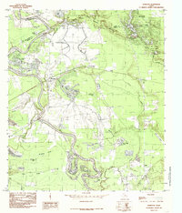
1984 Map of Romayor
USGS Topo · Published 1985About this map
The Trinity River snakes through the heart of this East Texas landscape, defining the boundaries where Liberty, San Jacinto, and Polk counties meet. The river's dynamic nature is evident in the numerous oxbow lakes and sloughs it has carved out over time, including Horseshoe Lake, New River Lake, and Brushy Lake. The settlement of Romayor serves as a local focal point near the river crossing, while the smaller communities of Milvid and Rye are situated further east. Significant portions of the northern and eastern reaches are protected within the Big Thicket National Preserve, characterized by dense bottomlands and seasonal wetlands like Wild Cow Marsh. The map reveals a mix of recreational and industrial use, from the Chain-O-Lakes Campgrounds near Hardwood Lake to a localized Gravel Pit and the Fields Landing Strip, reflecting the varied economic life of the Big Thicket region in the mid-1980s.
Find a feature on this map
39 named features on this map. Tap any name to fly to it.
Don’t see what you’re looking for? This feature index may not catch every label — zoom into the map to look around manually.
Map Details
Editions of this 1984 Romayor Map
This is the sole edition of this map. No revisions or reprints were ever made.
Other maps of this area

1943 · Liberty
USGS Topo · 1:125,000

1954 · Beaumont
USGS Topo · 1:250,000

1955 · Saratoga
USGS Topo · 1:62,500

1955 · Rayburn
USGS Topo · 1:62,500

1957 · Beaumont
USGS Topo · 1:250,000

1958 · Livingston
USGS Topo · 1:62,500

1958 · Segno
USGS Topo · 1:62,500

1984 · Segno
USGS Topo · 1:24,000

1984 · Beaumont
USGS Topo · 1:250,000
1984 · Goodrich
USGS Topo · 1:24,000