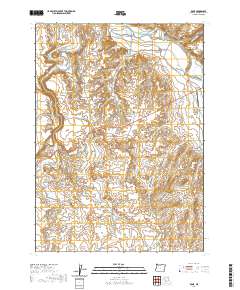
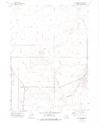
2020 Map of Rome
USGS Topo · Published 2020About this map
Rome serves as a remote hub for this High Desert landscape, situated near the confluence of the Owyhee River and Jordan Creek. The topography is defined by the steep Rome Cliffs and the deep incision of Owyhee Canyon, which together illustrate the erosive power of these water systems over geologic time. Land use in the area is largely characterized by cattle ranching and water management, evidenced by agricultural features like the Hubble Ditch, Happy Valley Ditch, and Scott Ditch that draw from Crooked Cr. Local infrastructure includes the Rome Service Airport and the settlement of Happy Valley to the north. Transportation through this part of Malheur County relies on a network of unpaved routes such as Kiger Rd and Old Ion Hwy, connecting the flat expanses of McCutcheon Flat to the surrounding canyons and gulches like Chino Gulch.
Find a feature on this map
26 named features on this map. Tap any name to fly to it.
Don’t see what you’re looking for? This feature index may not catch every label — zoom into the map to look around manually.
Map Details
Editions of this 2020 Rome Map
This is the sole edition of this map. No revisions or reprints were ever made.
Other maps of this area

1955 · Jordan Valley
USGS Topo · 1:250,000

1957 · Jordan Valley
USGS Topo · 1:250,000

1958 · Jordan Valley
USGS Topo · 1:250,000

1972 · Owyhee Butte
USGS Topo · 1:24,000

1972 · Rome
USGS Topo · 1:24,000
1972 · Scott Reservoir
USGS Topo · 1:24,000
1972 · Arock
USGS Topo · 1:24,000
1972 · Iron Mountain
USGS Topo · 1:24,000
1972 · Burns Junction
USGS Topo · 1:24,000

1979 · Rockhouse Reservoir
USGS Topo · 1:24,000