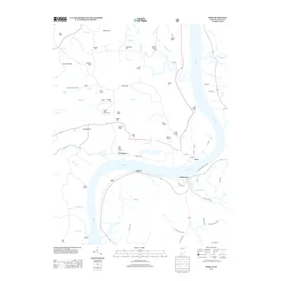
2013 Map of Rome
USGS Topo · Published 2013About this map
The Ohio River carves a deep meander through this borderland, separating the riverfront settlements of Rome and Hardingrove in Indiana from Stephensport and Addison in Kentucky. The landscape transitions from the broad floodplains of Anspaugh Flats and Harding Flats to the high, broken ground of German Ridge. This elevated terrain is dominated by the German Ridge Recreation Area, where the German Ridge Lookout Tower stands as a prominent landmark. Numerous smaller waterways like Poison Cr and Sinking Cr feed the main river artery, creating a network of hollows and ridges such as Link Hollow and Goosetown Ridge. The map details a rural landscape defined by family-named landmarks including Krausch Hill, Solomon Bryant Hill, and the striking Idle George Cliff overlooking the river. This topographical record illustrates the enduring relationship between the tight river bends and the upland forest communities that overlook them.
Find a feature on this map
76 named features on this map. Tap any name to fly to it.
Don’t see what you’re looking for? This feature index may not catch every label — zoom into the map to look around manually.
Map Details
Editions of this 2013 Rome Map
This is the sole edition of this map. No revisions or reprints were ever made.
Other maps of this area

1928 · Hardinsburg
USGS Topo · 1:48,000

1931 · Hardinsburg
USGS Topo · 1:62,500

1934 · Cannelton
USGS Topo · 1:62,500

1947 · Lodiburg
USGS Topo · 1:24,000

1947 · Hardinsburg
USGS Topo · 1:24,000

1947 · Hardinsburg
USGS Topo · 1:62,500

1949 · Cannelton
USGS Topo · 1:24,000

1950 · Alton
USGS Topo · 1:62,500

1950 · Alton
USGS Topo · 1:24,000

1951 · Alton
USGS Topo · 1:24,000