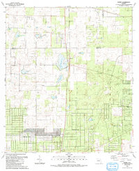
1991 Map of Romeo
USGS Topo · Published 1991About this map
Romeo and the surrounding karst landscape of Marion and Levy Counties are documented in this late-century survey, revealing a region defined by its distinct hydrologic features and developing residential subdivisions. The terrain is characterized by numerous prairies and ponds, such as Dry Cow House Prairie and Pine Island Prairie, which illustrate the natural drainage patterns of this Florida interior. In the southern portion of the quadrangle, organized growth is evident in the planned streets of Rainbow Lakes and Rainbow Park. For genealogists and local historians, the map identifies foundational community landmarks including Zion Hill Cem and several local congregations like Romeo Ch and Rainbow Lake Ch. The juxtaposition of established agricultural sites like Riverland against emerging residential pockets and scattered industry, such as a localized Sandpit, captures a specific era of transition for this part of north-central Florida.
Find a feature on this map
23 named features on this map. Tap any name to fly to it.
Don’t see what you’re looking for? This feature index may not catch every label — zoom into the map to look around manually.
Map Details
Editions of this 1991 Romeo Map
This is the sole edition of this map. No revisions or reprints were ever made.
Other maps of this area

1892 · Dunnellon
USGS Topo · 1:62,500

1894 · Dunnellon
USGS Topo · 1:62,500

1895 · Williston
USGS Topo · 1:62,500

1954 · Romeo
USGS Topo · 1:24,000

1954 · Dunnellon
USGS Topo · 1:24,000

1954 · Cotton Plant
USGS Topo · 1:24,000

1954 · Dunnellon SE
USGS Topo · 1:24,000

1954 · Yankeetown SE
USGS Topo · 1:24,000

1954 · Dunnellon
USGS Topo · 1:62,500

1954 · Gainesville
USGS Topo · 1:250,000