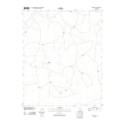
2010 Map of Romero SE
USGS Topo · Published 2010About this map
Minneosa Creek and its various tributaries define this section of the Texas Panhandle, carving a network of drainage channels that eventually feed into the Canadian River at the southern edge of the survey. The landscape is marked by the essential infrastructure of cattle ranching, where water management is paramount. Named water features like Van Tyle Tank, Red Tank, and Horseshoe Tank are distributed across the terrain, supplemented by a high density of specialized landmarks such as the Wooden Tower Windmill and Old Santa Fe Windmill. These features indicate a sophisticated system of land use and property division in Oldham County. Local history is etched into the map through family-named or descriptive sites including East Chavez Windmill, Freeze Out Windmill, and Poison Oak Windmill, providing specific points of reference for researchers tracing land tracts and historic ranch boundaries near Buck Arroyo.
Find a feature on this map
21 named features on this map. Tap any name to fly to it.
Don’t see what you’re looking for? This feature index may not catch every label — zoom into the map to look around manually.
Map Details
Editions of this 2010 Romero SE Map
This is the sole edition of this map. No revisions or reprints were ever made.
Other maps of this area

1954 · Tucumcari
USGS Topo · 1:250,000

1958 · Tucumcari
USGS Topo · 1:250,000

1966 · Big George Tank
USGS Topo · 1:24,000

1966 · Vat Camp
USGS Topo · 1:24,000

1966 · Trujillo Camp
USGS Topo · 1:24,000

1971 · Romero SE
USGS Topo · 1:24,000

1971 · Knoblaw
USGS Topo · 1:24,000

1971 · Spring Creek Ranch
USGS Topo · 1:24,000
1971 · Romero
USGS Topo · 1:24,000
1971 · Humdinger Spring
USGS Topo · 1:24,000