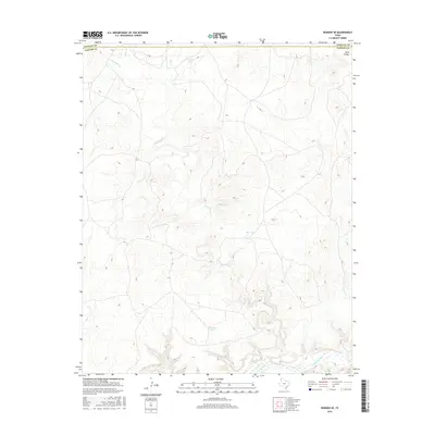
2016 Map of Romero SE
USGS Topo · Published 2016About this map
Canadian River bottomlands and the rugged breaks of the High Plains define this portion of the Texas Panhandle along the Hartley and Oldham county line. The landscape is characterized by a complex network of seasonal drainages, most notably Minneosa Cr, which carves a winding path toward the river through a series of dramatic contours. This modern survey illustrates the critical role of water management in this arid ranching environment, pinpointing numerous livestock water sources such as Horseshoe Tank, Red Tank, and Van Tyle Tank. These man-made features, alongside natural landmarks like Buck Arroyo and Spring Cr, provide essential orientation points in an area where the terrain itself dictates the location of roads and boundaries. The map's detailed topography reveals the deeply eroded canyons and plateaus that have historically influenced land use and cattle movement in this remote northern region.
Find a feature on this map
9 named features on this map. Tap any name to fly to it.
Don’t see what you’re looking for? This feature index may not catch every label — zoom into the map to look around manually.
Map Details
Editions of this 2016 Romero SE Map
This is the sole edition of this map. No revisions or reprints were ever made.
Other maps of this area

1954 · Tucumcari
USGS Topo · 1:250,000

1958 · Tucumcari
USGS Topo · 1:250,000

1966 · Big George Tank
USGS Topo · 1:24,000

1966 · Vat Camp
USGS Topo · 1:24,000

1966 · Trujillo Camp
USGS Topo · 1:24,000

1971 · Romero SE
USGS Topo · 1:24,000

1971 · Knoblaw
USGS Topo · 1:24,000

1971 · Spring Creek Ranch
USGS Topo · 1:24,000
1971 · Romero
USGS Topo · 1:24,000
1971 · Humdinger Spring
USGS Topo · 1:24,000