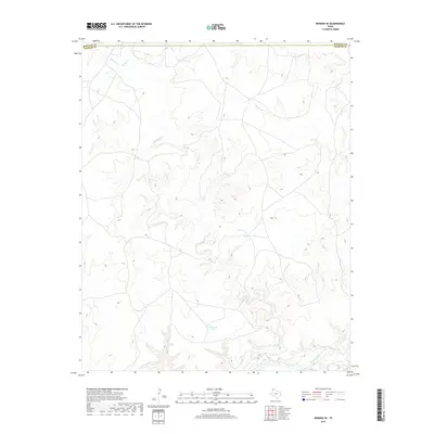
2019 Map of Romero SE
USGS Topo · Published 2019About this map
The Canadian River cuts through the southeastern corner of this High Plains landscape, where the border between Hartley County and Oldham County is defined by a series of drainage basins and isolated water sources. This 2019 survey documents a terrain dominated by ephemeral watercourses such as Minneosa Creek, Spring Creek, and Hay Creek. The area's reliance on managed water points for ranching and agriculture is evident through several named depressions and impoundments, including Van Tyle Tank, Red Tank, and the uniquely shaped Horseshoe Tank. While formal settlements are absent on this specific sheet, the intricate network of local roads and water features reflects the enduring cattle country infrastructure of the Texas Panhandle. Modern topographical details captured by the U.S. Geological Survey highlight the erosion patterns leading toward the river valley, providing a clear view of the rural geography in this remote border region.
Find a feature on this map
8 named features on this map. Tap any name to fly to it.
Don’t see what you’re looking for? This feature index may not catch every label — zoom into the map to look around manually.
Map Details
Editions of this 2019 Romero SE Map
This is the sole edition of this map. No revisions or reprints were ever made.
Other maps of this area

1954 · Tucumcari
USGS Topo · 1:250,000

1958 · Tucumcari
USGS Topo · 1:250,000

1966 · Big George Tank
USGS Topo · 1:24,000

1966 · Vat Camp
USGS Topo · 1:24,000

1966 · Trujillo Camp
USGS Topo · 1:24,000

1971 · Romero SE
USGS Topo · 1:24,000

1971 · Knoblaw
USGS Topo · 1:24,000

1971 · Spring Creek Ranch
USGS Topo · 1:24,000
1971 · Romero
USGS Topo · 1:24,000
1971 · Humdinger Spring
USGS Topo · 1:24,000