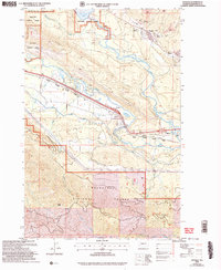
2003 Map of Ronald
USGS Topo · Published 2006About this map
Coal mining heritage and mountain transport routes define the landscape around Ronald and Roslyn in this Kittitas County survey. The northern portion of the map is heavily marked by the region's industrial past, featuring the Roslyn-Cascade Mine No 4, No 3 Mine, and several Strip Mines, alongside numerous Adits and Mine Dumps. These operations sit just below the steep ascent of Easton Ridge and the Domerie Flats near the southern shore of Cle Elum Lake.
Find a feature on this map
36 named features on this map. Tap any name to fly to it.
Don’t see what you’re looking for? This feature index may not catch every label — zoom into the map to look around manually.
Map Details
Editions of this 2003 Ronald Map
This is the sole edition of this map. No revisions or reprints were ever made.
Other maps of this area

1897 · Mount Stuart
USGS Topo · 1:125,000

1901 · Snoqualmie Pass
USGS Topo · 1:125,000

1902 · Mount Stuart
USGS Topo · 1:125,000

1903 · Snoqualmie
USGS Topo · 1:125,000

1957 · Wenatchee
USGS Topo · 1:250,000

1958 · Cle Elum
USGS Topo · 1:62,500

1961 · Mount Stuart
USGS Topo · 1:62,500

1961 · Easton
USGS Topo · 1:62,500

1961 · Kachess Lake
USGS Topo · 1:62,500

1975 · Snoqualmie Pass
USGS Topo · 1:100,000