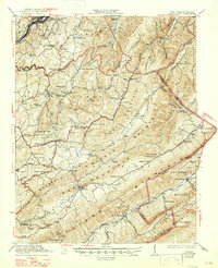
1923 Map of Ronceverte
USGS Topo · Published 1947About this map
Peters Mountain and Allegheny Mountain dominate this landscape, defining the rugged borderlands where West Virginia and Virginia meet. The area is characterized by a dense network of mountain ridges including Kates Mountain and Slaty Mountain, which separate narrow valleys where the region's life was centered in the early 1920s. Along the Greenbrier River, the town of Ronceverte serves as a transportation hub for the Chesapeake and Ohio railroad, while further south, the Norfolk and Western line skirts the edge of the Jefferson National Forest near Paint Bank.
Find a feature on this map
106 named features on this map. Tap any name to fly to it.
Don’t see what you’re looking for? This feature index may not catch every label — zoom into the map to look around manually.
Map Details
Editions of this 1923 Ronceverte Map
4 editions found

Other maps of this area

1887 · Hinton
USGS Topo · 1:125,000

1887 · Lewisburg
USGS Topo · 1:125,000

1890 · Dublin
USGS Topo · 1:125,000

1890 · Christiansburg
USGS Topo · 1:125,000

1891 · Lewisburg
USGS Topo · 1:125,000

1891 · Dublin
USGS Topo · 1:125,000

1892 · Hinton
USGS Topo · 1:125,000

1921 · Callaghan
USGS Topo · 1:48,000

1921 · Alderson
USGS Topo · 1:48,000

1921 · White Sulphur Springs
USGS Topo · 1:48,000