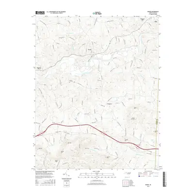
2016 Map of Ronda
USGS Topo · Published 2016About this map
The Yadkin River defines the central corridor of this Wilkes County landscape, winding past the riverside community of Ronda and the junction at Roaring River. This region is characterized by its transition from the river valley to the prominent heights of the Brushy Mountains in the south, where family-named peaks like Mathis Mtn and Redding Mtn dominate the topography. Local history is anchored by the Old Brier Creek Cem and scattered settlements such as Clingman and Pleasant Hill, which serve as waypoints along a network of country roads including Macedonia Church Rd. The terrain is deeply textured with numerous hollows and knobs, such as Dobbins Hollow and Gobblers Knob, illustrating the complex drainage patterns of creeks like Little Bugaboo Cr and Swan Cr as they feed into the primary river system.
Find a feature on this map
116 named features on this map. Tap any name to fly to it.
Don’t see what you’re looking for? This feature index may not catch every label — zoom into the map to look around manually.
Map Details
Editions of this 2016 Ronda Map
This is the sole edition of this map. No revisions or reprints were ever made.
Other maps of this area

1889 · Wilkesboro
USGS Topo · 1:125,000

1891 · Wilkesboro
USGS Topo · 1:125,000

1891 · Yadkinville
USGS Topo · 1:125,000

1893 · Yadkinville
USGS Topo · 1:125,000

1953 · Winston-Salem
USGS Topo · 1:250,000

1955 · Winston-Salem
USGS Topo · 1:250,000

1962 · Winston-Salem
USGS Topo · 1:250,000
1966 · Gilreath
USGS Topo · 1:24,000

1966 · Roaring River
USGS Topo · 1:24,000
1968 · Traphill
USGS Topo · 1:24,000